We’re working with the Chicago Department of Transportation (CDOT) to help make your bus ride better. The Bus Priority Zone (BPZ) program identifies ways to make buses travel faster and provide more reliable service along some of Chicago's busiest corridors.
Overview
Through the Bus Priority Zone Program our goal is to unsnarl what we call “bus slow zones,” which are often caused by traffic congestion, insufficient space for bus boarding, or a major intersection that creates a bottleneck. What we've found is that these bus slow zones not only affect the quality of bus service in that particular area, but they also create a ripple effect of delays and bus bunching—this negatively impacts travel times and service reliability across the entire route.
By using elements from the Better Streets for Buses Toolbox of Street Treatments to give priority to buses, these targeted projects are intended to make bus operations smoother and address specific slow segments and pinch-points for buses, creating “Bus Priority Zones.”
Several Bus Priority Zone projects were constructed in 2019 on portions of some of the city’s most heavily traveled corridors: 79th Street, Chicago Avenue, LaSalle Street, Wacker Drive, and Western Avenue.
After the success of this first-round of BPZ implementation, CTA and CDOT are pursuing this strategy along several additional corridors, including Ashland Avenue, Halsted Street and 63rd Street.
One size does not fit all; CTA and CDOT looked at each of the slow zone segments to determine what could help reduce delays given the existing street configuration and context. Improvements made under the Bus Priority Zone program may include elements such as:
- Designated bus lanes, which could be in effect all-day or just on weekday rush hour period(s), depending on location. These are often indicated with new pavement markings, including red paint, and signage.
- Queue jump signals, special bus-only signals which would give buses a head start from regular traffic at intersections.
- Sidewalk reconfiguration, such as a curb extension to shorten crossing distances for pedestrians or creating a new cul-de-sac to simplify complex intersections. These projects can create a better environment for pedestrians and those waiting for the bus.
- Signal timing optimization to make sure streets with major bus routes get the appropriate signal time.
- Optimization of bus stop locations, such as moving a stop from the “near side” of an intersection to the “far side,” so that buses can keep moving after customers have boarded.
- Other streetscape improvements, such as street resurfacing, improved pedestrian crossings, or concrete bus pads that help preserve the street at bus stops.
Benefits
Public bus service plays a vital role in Chicago’s robust transportation network and adds great value to the local economy. By prioritizing bus service, we’re improving the travel experience for our current riders and encouraging more people to take the bus by making public transit a more attractive travel option. Addressing a specific slow zone along a route can also improve performance and reliability for the whole route. In some cases, the improvements we’re making as part of the BPZ program will also improve the pedestrian environment, making the street and sidewalks safer and more accessible for all users. With BPZs, CTA and CDOT can better organize traffic as well—and when all road users have their designated space, the street works better for everyone.
BPZ projects
79th Street at Martin Luther King Jr. Drive
Served by the #79 bus route, this segment of 79th Street connects to the neighborhoods of Greater Grand Crossing and Chatham. Signal Timing Optimization at this intersection will improve bus service and traffic flow in the area. Signal Timing Optimization at this intersection was implemented to improve bus service and traffic flow in the area.
79th Street: Spaulding Avenue to Kedzie Avenue
Served by the #79 bus route, this segment of 79th Street between Spaulding and Kedzie consisted of three closely spaced intersections—Sawyer, Columbus and Kedzie—forming a complex triangle that added to congestion and created potential vehicle conflicts. To help improve bus service, safety, and traffic flow in the area, the following improvements were made:
- Cul-de-sac installation at Sawyer Avenue north of 79th Street to simplify the intersection and expand pedestrian space
- Installation of red bus lanes, in effect 24 hours and 7 days a week, with overhead “Bus Only Lane” signs
- Signal timing optimization
- A bus queue jump signal was installed at eastbound 79th/Kedzie
- Bus pads
79th Street at Halsted Street
Served by the #79 bus route, this stretch of 79th Street between Green and Emerald connects to the neighborhood of Auburn Gresham and the Halsted corridor. To help improve bus service and traffic flow in the area, this Bus Priority Zone project included the following improvements:
- Installation of red bus lanes in effect during rush hours, with overhead “Bus Only Lane” signs
- Signal timing optimization
79th Street at the Red Line 79th Station
Served by the #79 bus route, stops along the segment of 79th Street between Perry and Wabash connect riders to the Red Line and see some of the highest ridership along the corridor. To help improve bus service, safety, and traffic flow in the area, this Bus Priority Zone project included the following improvements:
- Installation of red bus lanes, in effect 24 hours and 7 days a week, with overhead “Bus Only Lane” signs
- A bus queue jump was installed at westbound 79th/Lafayette
- Signal timing optimization
- Reconfigured pedestrian refuge islands
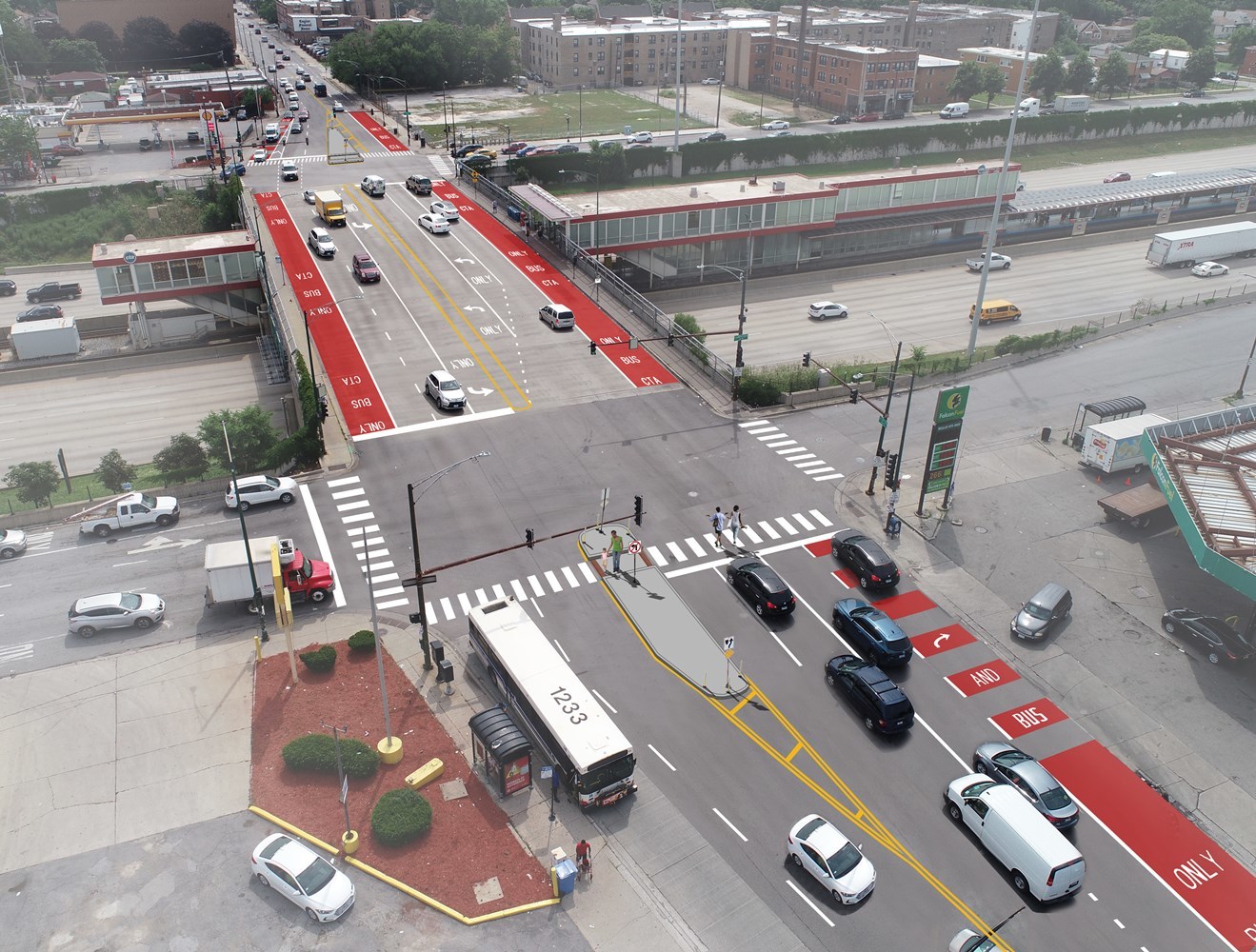
Chicago Avenue at the Blue Line Chicago Station
_Overview.PNG)
Served by the #66 Chicago bus route, this segment of Chicago Avenue between May and Sangamon connects riders to the Blue Line and includes some of the highest ridership bus stops in the entire CTA bus system. To help improve bus service, safety, and traffic flow between three closely-spaced intersections in the area, the following improvements were made:
- Installation of red bus lanes in effect during rush hours, with overhead “Bus Only Lane” signs
- Cul-de-sac installation at the north leg of May Street to simplify the intersection and expand pedestrian space
- Improved bus stop boarding area for the westbound bus stop near the Blue Line entrance
- New curb extension on southeast corner of May/Chicago for improved pedestrian safety
- Extended left turn lane (from westbound Chicago onto southbound Ogden)
_Renderings.PNG)
Chicago Avenue: Larrabee to Michigan
Served by the #66 Chicago bus route, this segment of Chicago Avenue connects the neighborhoods of River West, Cabrini Green, River North, Streeterville and the Magnificent Mile along Michigan Avenue. To help improve bus service, pedestrian safety, and congestion in the area the following improvements were made:
- Installation of red bus lanes in effect during rush hours, with overhead “Bus Only Lane” signs
- Bus queue jump signals were installed at westbound Franklin/Chicago and eastbound Clark/Chicago
- Signal timing optimization
- Bus pads
- Curb extensions for improved pedestrian safety at Cleveland, Hudson, Wells, Clark, and Wabash
- Relocation of bus stop shelters at Clark Street (from near side to far side), for improved operations
- Street resurfacing
Chicago Avenue: Campbell to Ashland
Served by the #66 Chicago in Chicago’s West Town. To help improve bus service, safety, and congestion in the area, the following improvements were implemented:
- Red, bus-bike lanes in effect 24 hours and 7 days a week.
- Improved pedestrian safety at several intersections by extending sidewalk space and shortening the crossing distance using paint-and-post bumpouts
LaSalle Street at Wacker Drive
This location is served by the #134 Stockton/LaSalle Express, #135 Clarendon/LaSalle Express, #136 Sheridan/LaSalle Express, and the #156 LaSalle bus routes, and experiences very high ridership during peak travel periods. To allow buses to better navigate in and out of traffic as they serve the southbound stop, new pavement markings were added to help keep the bus stop clear of unauthorized vehicles.
Wacker Drive at Michigan Avenue
Bus stops at this location serve the #2 Hyde Park Express #6 Jackson Park Express #134 Stockton/LaSalle Express, #135 Clarendon/LaSalle Express, #136 Sheridan/LaSalle Express, #146 Inner Drive/Michigan Express, and #148 Clarendon/Michigan Express bus routes, with very high ridership during the peak travel periods. To help improve bus operations, new pavement markings were added to better demarcate the eastbound bus stop area to help keep the bus stop clear of unauthorized vehicles.
Western Avenue at the Blue Line Western Station
Served by the #49 Western and the #X49 Western Express bus routes, stops along this segment of Western Avenue between Bloomingdale and McLean connect to the Blue Line and see some of the highest ridership along the corridor. To help improve bus service, safety, and congestion in the area, the following improvements have been made:
- Installation of red bus lanes in effect during rush hours, with overhead “Bus Only Lane” signs
- Signal timing optimization
- Bus pads
- New pedestrian refuge island at Cortland
- Curb extensions to shorten walk distances across Armitage and Wilmot
- Street resurfacing
More info